Monday, February 18, 2013

Feb 19th Snow Event

Precipitation Type

Confidence: 90%


Snowfall Totals

Confidence: 85%


-biggamefisherman1000

Saturday, February 16, 2013

Extreme Cold Likely Later This Month In Through March

NAO


AO


PNA


The Temperature Pattern


-biggamefisherman1000

Tomorrow's Snowstorm

I do see the Navy (NOCAPS) against saying I will get a good amount of snow. Could that model be right, yes be I don't think I'll see that in Central NJ. The 0z is being updated right now. We'll see whne the 0z models come out. As of know in the map below, this is what I'm seeing. This upcoming week, I see a more moist northern stream. The follow weak after the upcoming we could see a moist southern stream. Just because the two storms are not sea surface anomaly storms does not mean they can't intense blizzards. My final forecast for this storm will come out tomorrow.

SNOWFALL TOTALS

Confidence: 80%


-biggamefisherman1000

Snow today

This is a snowfall map of who is going to see the most snowfall. my thoughts havent changed from yesterdays thinking of 1"-3" inches possibly higher up to 5" and 6" inches from Durham to Wilson.
I think we will also see about C- 2" from Greensboro to Roxboro and to Asheville. In the other color that is where there is possible snow.

Friday, February 15, 2013

East coast snow storm, February 16th and 17th

This is just going to be a real quick post on the "snowstorm" on Saturday afternoon and Sunday morning. Areas from Durham North Carolina to Wilson, is my rough estimate of where the most snow is going to be. This is where I think that there is a possibility of anywhere between 1"-3" locally up to 5 or this might be too high, but 6" inches. Anywhere between Asheville and Greensboro and between Wilson and Jacksonville there is the chance to get between a coating and 1" inch this storm will affect places as far south as South Carolina and as far north as Maine, you might have to count on Andrew to post about that, I will have a much more in depth blog tomorrow morning and one on Sunday to see if my thoughts verify.

Thursday, February 14, 2013

NJ Minor Snow Event For Feb 16th

Precipitation Type

Confidence: 75%


Snowfall Totals

Confidence: 70%


-biggamefisherman1000

Snowstorm Around Feb 17th-19th?

This is a moderate is that possible for the northeast. I will predict on this tomorrow. We even got more storms after the upcoming. In Central NJ, I am right now at 31 inches which is 31 inches above average. Look at the totals for every storm that occurred. Wait for updates.

Link: http://biggamefisherman1000snowreporter.blogspot.com/2013/02/as-of-now-21413-annual-snowfall-oct.html

-biggamefisherman1000

Wednesday, February 13, 2013

Snowfall Totals For Tonight

Precipitation Type

Confidence: 90%


Snowfall Totals

Confidence: 85%


Chances of School Delays

Confidence: 95%


-biggamefisherman1000

Tuesday, February 12, 2013

NJ Snow For Tomorrow Night

Precipitation Type

Confidence: 85%


Snowfall Totals

Confidence: 80%


-biggamefisherman1000

Monday, February 11, 2013

Major Snowstorm For Thursday and Friday

Now, the GFS is indicating most of this and actually indicating blizzard conditions. The 12z Canadian is indicating the same. But not most of the Canadian. The NAM is indicating a little inland but still a nice snowstorm. Throw out the Euro with this storm because it's either indicating this storm as a progressing storm or out to sea! But maybe the Euro could top these models tomorrow. Let's get to my predictions for this possible upcoming storm.

Precipitation Type

Confidence: 45%


Snowfall Totals

Confidence: 40%


Note: My confidence is 40%-45% with this outlook. That means this could change. Next outlook could be around 60%. Also, there is another storm coming that will have much more intense winds and possible record snowfall for New York to Boston. So wait for updates.

-biggamefisherman1000


Snowstorm Feb 13th-15th Model Indications

Model's Predicted Storm Tracks


GFS IMPACTS


NAM IMPACTS


CANADIAN IMPACTS


Note: I'm am going to school. I will update this when I get back. But as of today, throw out the EURO!!! The euro is not looking correct for this storm. But who knows, it's been tracking better today then yesterday. So euro could top the GFS. But the GFS looks accurate with the storms and has been indicating this storm even three days ago. So that proves to you that the GFS could be doing a good job. Wait for updates.

-biggamefisherman1000

Sunday, February 10, 2013

NJ Tonight Possible Ice Threat

There is minor icing possible in areas of New Jersey. The are freezing rain advisories going over parts of Central  New Jersey but not my county. I am going to show you my predictions for this minor ice event. There could also be a little snow and sleet with this storm.

Freezing Rain Locations


Chances of School Delays


-biggamefisherman1000

Possible Feb 13th-14th Snowstorm

This storm is a very interesting for tracking especially when the models are disagreeing with each other. Don't say the GFS will be correct because you want more snow. I'm not saying the other models cannot be correct. 


Possible Storm Tracks


Note: The NAM needs a few more hours so I could tell the NAM's impacts. But as of now, the Canadian and the GFS are indicating impact to the northeast.


The GFS Impacts


The Canadian Impacts


-biggamefisherman1000

Saturday, February 9, 2013

Website For My Snow Reports

Here is a link to find out how much snow I have. It's another blog I created so none of you could tell me how much snow I have. I don't have 18 inches but I have 29.5 inches. 0.5 inches away from my average. After storms involving snow, that blog will have the reports.

Link:  http://biggamefisherman1000snowreporter.blogspot.com/


-biggamefisherman1000

The Timezone Of The Blog Is Correct Now

Finally, I found out how to fix it. Before, it was set to Pacific Time. Now I changed it to Eastern time. Sorry for that.

-biggamefisherman1000

Anyone Want to Forecast On This Blog?

SPOTS OPEN:


Note: If you want to join, email biggamefisherman1000@yahoo.com if you want to forecast on this website. 

-biggamefisherman1000

Blizzard Feb 14th-15th?

Yes, the GFS is indicating this. And then an even more major one after. The second one after the upcoming one looks to be record breaking and possibly even snow at the Gulf Coast (GFS Precipitation Ensembles). The first system looks to be all snow for NJ and 24 inches+. If this storm stands out, I'll do an outlook on this either tomorrow or Monday.

GFS: http://www.meteo.psu.edu/~fxg1/AVN_0z/avnloopnew.html

GFS Precipitation Ensembles: http://www.meteo.psu.edu/~fxg1/ENSPRS_0z/ensloopnew.html

Note: Black is the freezing line!!!

-biggamefisherman1000

Feb 8th Storm Report

About what I thought. I got 9 inches in Central NJ. Notice I stated "At least 6 inches for Central NJ". So I was in the range of 6-18 inches. I was expecting 12 inches but got a little less. But it was a nice moderate snowstorm I will have to shovel later. Not snowing at 7:44 AM.

-biggamefisherman1000 

Friday, February 8, 2013

Final NJ Snowfall Storm Totals

Finally, the snowfall are like 0.5-1 in. an hour as of 10:44. At least 6 inches for Central NJ. Now it's looking major. It's snowing crazy. The snow is heavier now.


SNOWFALL TOTALS

Confidence: 97.5%


-biggamefisherman1000

Updated NJ Storm Snowfall Totals

Snowfall Totals

Confidence: 95%


-biggamefisherman1000

This Major Storm Snows For NJ

@New Jersey Residents

Even parts of NJ need to take action. I got requested this by my friends asked badly for this. So I respect that. As of now 3:50 (Don't look at the Upload Time. It's Mountain time). The reason why you see Northeast NJ rather than Northwest NJ with that 18+ because this is a coastal nor'easter. Not an Apps. Runner. Wait for updates.


Snowfall Totals

Confidence: 92.5%


-biggamefisherman1000

Thursday, February 7, 2013

GO OUT TO SEA ALREADY!!! NEW ENGLAND POSSIBLE RECORD BREAKING STORM

Folks, this is a serious nor'easter for the northeast. Heavy rain, some ice and sleet, all changing over to very heavy snow.  Take action New York to Boston.

Models I used for this storm. Temperatures is the bottom right corner. Precipitation is in millimeters in rain.:


GFS: http://www.meteo.psu.edu/~fxg1/AVN_0z/avnloopnew.html

GFS Precipitation: http://www.meteo.psu.edu/~fxg1/ENSPRS_0z/ensloopnew.html

Canadian: http://www.meteo.psu.edu/~fxg1/CMC_0zA/cmcloop.html

Euro: http://www.meteo.psu.edu/~fxg1/ECMWF_0z/ecmwfloop.html


STORM TRACK

Confidence: 90%

PRECIPITATION TYPE

Confidence: 85%

SNOWFALL TOTALS

Confidence: 82.5%

-biggamefisherman1000

Wednesday, February 6, 2013

Major Snowstorm for The Northeast Feb 8th-9th

Folks, I'm am tried of the trash talk and bashing. I actually see a winter storm watch in my county in Central NJ (not telling you which). Check these links and look. Bottom right for temps. Black line is the freezing. Precipitation is in millimeters of rain not snow. If you use weather bell and accuweather pro, great. Don't do bash this website with Allan's website. He doesn't update often (I check for days and never see it update).

GFS: http://www.meteo.psu.edu/~fxg1/AVN_0z/avnloopnew.html

GFS Precipitation: http://www.meteo.psu.edu/~fxg1/ENSPRS_0z/ensloopnew.html

Canadian: http://www.meteo.psu.edu/~fxg1/CMC_0zA/cmcloop.html

Euro: http://www.meteo.psu.edu/~fxg1/ECMWF_0z/ecmwfloop.html

Okay let's get to the forecast.


LIKELY STORM TRACK

Confidence: 70%


GFS PRECIPITATION TYPE:


CANADIAN PRECIPITATION TYPE:


EURO PRECIPITATION TYPE:
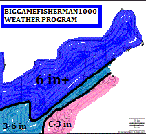
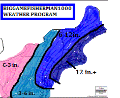

SNOWFALL TOTALS

Confidence: 70%


-biggamefisherman1000

Tuesday, February 5, 2013

Oh Gosh!!! Possible Blizzard for the Northeast on Feb 8th-9th

POSSIBLE STORM TRACKS

Confidence: 40%


Note: The sea surface and 40-70 benchmark make the storm more intense. I'm with the Euro because it's USUALLY more accurate. Sometimes the Canadian and GFS could top but not usually. I hated how the models shifted east (except the Canadian). Let's hope it's an App. Runner or out to sea like the NAM because I want to go fishing this weekend.


PRECIPITATION TYPE:

Confidence: 45%


SNOW DETECTOR

Confidence: 50%


SNOWSTORM WIND DETECTOR

Confidence: 40%


SNOWFALL TOTALS:

Confidence: 35%


-biggamefisherman1000

Monday, February 4, 2013

Possible Storm Feb 8th-9th

POSSIBLE STORM TRACK


EURO IMPACTS

Confidence: 25%


CANADIAN IMPACTS

Confidence: 15%


Note: My confidence is low. Do not put 100% confidence into this. I think the Euro will most likely be correct because it is usually more accurate. The GFS and Nam are indicating out to sea. Wait for updates, things will change as time goes on.

-biggamefisherman1000

Sunday, February 3, 2013

Storm Feb 8th-9th 2013?

The euro is as of now indicating major snowstorm except for Cape Cod. The Canadian is indicating a more inland solution as is 50/50 and most like rain for central NJ. I might update tomorrow if this storm stands out.

-biggamefisherman1000


Friday, February 1, 2013

Feb 2013 Forecast And Oct 2012-May 2013 Minimum Annual Snowfall

OVERALL CONDITIONS


HIGHS


SNOW OUTLOOK


OCT 2012-MAY 2013 MINIMUM ANNUAL SNOWFALL


My spring and summer forecast for this year will come out soon. Still waiting till the proper time to post. Keep looking at this webpage for updates and NJ fishing reports. 

-biggamefisherman1000